The LA sprawl boasts a surprising number of outdoor oases — if you know where to look.
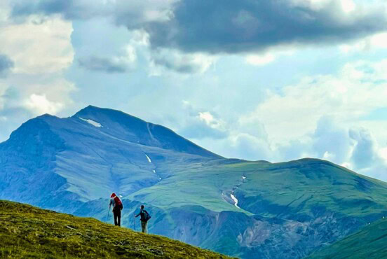
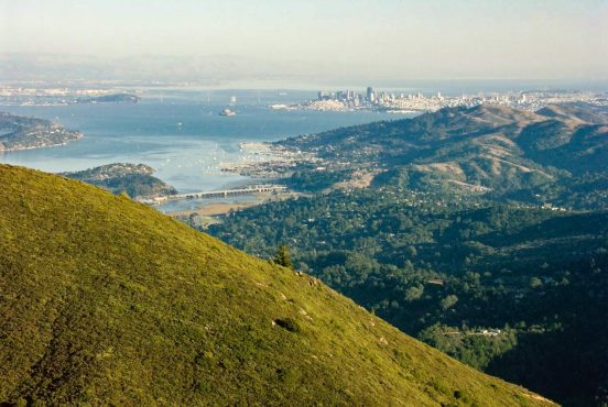
When people think about Los Angeles, they probably don’t think about awesome hiking access. Starlets and tech millionaires driving Teslas? Sure, but not outdoor recreation. However, with the massive (and recently expanded) San Gabriel National Monument, Santa Monica Mountains and Griffith Park all situated within an hour’s drive of the City of Angels, there’s a wealth of peaks, valleys and coastline to explore.
As someone who lived and adventured in Los Angeles for nearly 19 years, I know the importance of nearby nature and urban hiking more than most. When I worked as an executive assistant in Hollywood, I was typically chained to my desk for at least 40 hours per week, and would then speed off to the nearby mountains every Saturday and Sunday in search of the most scenic trails.
Below are my 11 favorite day hikes near Los Angeles, with something for everyone at every fitness level.
*All distances listed are round-trip

Mount Baldy
Distance: 11 miles
Elevation gain: 3,990 feet
Trailhead access: Manker Flats – Mt. Baldy Trailhead
You’ve likely seen this bald-topped, snow-capped peak popping up behind the LA skyline in long lens photos of the city in wintertime. Mount San Antonio, or Mount Baldy as it’s colloquially called by SoCal natives, is the highest point in Los Angeles County at 10,064 feet. As such, it’s a long slog to reach the summit, and the trail is only snow-free from late spring through fall.
The good news? If the chairlift is running, you can skip a huge portion of the ascent or descent and cruise up or down the mountain with fantastic seated views. I’ve done this hike more times than I can count, usually while training for high altitude Sierra Nevada pursuits, and it never falls short of magical.
Start in the morning near Manker Flats Campground where you’ll park in a large lot. Then, hike up the winding dirt road to Top of the Notch, where there’s a restaurant, bathrooms and water refill stations. From here, you’ll veer left and head up the notorious Devil’s Backbone Trail where the slopes fall away steeply on both sides of the narrow path, offering breathtaking views of the surrounding San Gabriel Mountains. Once you tag the summit (which sits blissfully just above tree line), return the way you came or make a loop by trekking downhill via the Baldy Bowl Trail.
Mishe Mokwa Trail to Sandstone Peak
Distance: 5.9 miles
Elevation gain: 1,354 feet
Trailhead access: Mishe Mokwa Trail
I’ve seen websites tout this trek as being the best hike in all of Los Angeles, and it’s hard to disagree. Though the area was devastated by a fire a few years back, the colorful pops of wildflowers, rust-orange sandstone outcroppings and Pacific Ocean views make this a trail I always recommend.
For an easier uphill journey, park at the Mishe Mokwa Trailhead (there’s a large dirt lot), then meander around canyons and hills studded with coastal chaparral. Roughly 4.5 miles in, you’ll reach the summit, and that’s an excellent spot for a lunch break before the steep downhill back to your car.
Pro tip: it can be easy to miss a last-minute left hand turn to get back to the correct parking lot for Mishe Mokwa. Stave off your ravenous hiker hunger with a trip to legendary Neptune’s Net when you’re done.

Bridge to Nowhere
Distance: 10 miles
Elevation gain: 1,255 feet
Trailhead access: East Fork Day Use Parking
The trek to Bridge to Nowhere is a moderate hike that meanders back and forth across the East Fork of the San Gabriel River. As such, it’s increasingly popular on warm, sunny days and summer weekends. To complete this trip, you’ll want to arrive before 9am to secure a parking spot.
Once on the trail, you’ll feel a million miles away from Los Angeles as you trek along the edges of crumbling granite gorges, gleaning better and better views of the San Gabriel Mountains until a short stroll along a dusty ridge takes you to the Bridge to Nowhere itself. Built in 1936, they began construction for the bridge to be part of a highway connecting the San Gabriel Valley to Wrightwood but was never completed.
Scurry across the bridge and follow a use trail down the rounded gray boulders to get an even better view of the arch bridge. If you’re lucky, you may spot a series of bungee jumpers taking the leap.
Solstice Canyon Loop
Distance: 3 miles
Elevation gain: 669 feet
Trailhead access: Solstice Canyon Education Center
Solstice Canyon is one of the prettiest hikes in the Santa Monica Mountains, climbing up a ridge with phenomenal views of the Pacific’s sapphire waves before descending to the ruins of an abandoned homestead and a small waterfall — one of the rare perennial freshwater sources in the area.
Bring plenty of water with you on this trek, as the first part of this counterclockwise loop (the Rising Sun Trail) is sunny and exposed. About 1.5 miles into the arid ridge climb, hikers will come across the ruins of the Tropical Terrace House, which was once a noteworthy landmark circa-1952.
The good news: after you’re done checking out the crumbing brick façade, you’ll have a mostly shaded journey back to the car.
Mount Hollywood
Distance: 5 miles
Elevation gain: 1,010 feet
Trailhead access: Ferndell, Griffith Park
Starting in a lush, landscaped park that’s reminiscent of a vintage Pacific Northwest postcard and finishing atop one of LA’s most iconic peaks, this trip from Ferndell is my all-time favorite way to summit Mt. Hollywood. Plus, it’s close enough to the city to complete as an after work hike during summer months, when the sun sets late.
Park off the side of the road near Trails Cafe, then look for a wide dirt path in the trees heading towards Griffith Observatory. Roughly one mile and 500 feet of climbing into the trip, you’ll reach the famed observatory, and it’s well worth reserving some time to walk around this 1935-era landmark, if only to check out the sweet views from its wrap-around deck.
From here, traverse the large parking lot and get ready to climb up, up, up the dusty trail to the top of Mt. Hollywood. Enjoy the panoramic views of the sprawling cityscape before returning the way you came or looping down along the West Trail.
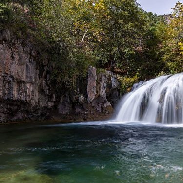
Switzer Falls
Distance: 3.6 miles
Elevation gain: 700 feet
Trailhead access: Switzer Picnic Area
Situated just north of Pasadena, not far along the winding Angeles Crest Highway, is one of the best moderate hikes near the City of Angeles. Be forewarned, though, this is an incredibly popular route, and parking often fills by 9am on weekends.
Begin at the Switzer Picnic area, which — unlike much of Southern California —is shaded and hugs the Arroyo Seco for most of the trek. Take your time to indulge in this rare, lush riparian area as you stroll along a mostly flat gravel bank. When you reach what looks like the trail’s end, you’ll veer right and ascend a scrubby slope that offers jaw-dropping views of the inner San Gabriels.
Descend to the cascade and its adjacent swimming hole, which is a great spot for an afternoon picnic. Just be sure to save some energy for the climb out of the canyon when you return the way you came.

Mount Baden-Powell
Distance: 8 miles
Elevation gain: 2,775 feet
Trailhead access: Vincent Gap
Partially because it’s a 90-minute drive from the city and partially because of its thigh-busting 2,775 feet of climbing, this is often a wonderfully uncrowded and scenic trail outside the tiny mountain hamlet of Wrightwood.
Ever wanted to day hike a portion of the Pacific Crest Trail? This is your moment. The trail begins at the large parking area for Vincent Gap and wastes no time in climbing up a series of conifer-shaded, well-graded switchbacks for nearly the entirety of the hike. Fear not, because there are peekaboo views into the heart of the San Gabriel Range that make this ascent anything but boring.
Near the summit, you’ll traverse an airy ridge (no scrambling required) with awe-inspiring views of Mt. Baldy and the surrounding high peaks. Want an even more challenging and less crowded way to summit Mt. Baden-Powell? Check out the 16-mile trip up from Islip Saddle.

Strawberry Peak via Colby Canyon
Distance: 6.6 miles
Elevation gain: 2,703 feet
Trailhead access: Colby Canyon Trailhead
This challenging route up Strawberry Peak is technically a mellow class 3 scramble, but the rock is solid and the route finding is easy enough that it’s a great starter scramble for those training for bigger peaks in the Sierra Nevada. Plus, because it begins at an obscure trailhead with a small parking area, it’s generally an uncrowded hike—a rare thing in a metro area of 12.5 million people.
The trail begins in a lush, wooded canyon with a stream trickling through it and ascends steadily for the first 2.2 miles to Josephine Saddle. Sip some water and grab a snack here, because you’ll soon be taking a sharp right turn onto a rocky, granite ridge and scrambling up a few hundred feet of steep boulders until you reach the summit and its sweeping vistas.
Return the way you came or turn your trek into an all-day, 11.5-mile loop by taking the maintained trail down from the summit of Strawberry.

Parker Mesa Overlook
Distance: 7.5 miles
Elevation gain: 1,597 feet
Trailhead access: Los Leones Trailhead
Following one of the lushest riparian canyons in the entire Santa Monica Mountains National Recreation Area (go in the spring and thank us later), this trail up to the Parker Mesa Overlook eventually opens up to 180-degree Pacific Ocean views.
It’s a quintessentially LA hike, with a little something for everyone: forests carpeted in ivy, a leg-burning climb and a picture-perfect park bench at the end to soak in all those epic views. Park in the small lot for the Los Leones Day Use Trail and get ready to climb in an undulating manner for nearly 1,600 feet before reaching the turnaround point.
Oh, and good news, there’s a random backcountry toilet just before the overlook. You’re welcome.
Echo Mountain
Distance: 5.3 miles
Elevation gain: 1,420 feet
Trailhead access: Loma Alta Drive, near the Cobb Estate
Yet another fantastic east side trail, this hike begins in the posh, wooded foothills of Altadena, near the supposedly haunted Cobb Estate. The trail quickly crosses Las Flores Creek before following a series of switchbacks up the steep, arid slope of Echo Mountain for nearly the entirety of its length. Be sure to stop, turn around and enjoy the view from time to time, since you’ll glean increasingly impressive panoramas of Pasadena and downtown Los Angeles on a clear day.
On the summit of Echo Mountain, hikers will find the sincerely fascinating ruins of the historic Mt. Lowe Railroad, which used to bring travelers up to the since-demolished Echo Mountain Resort as a respite from the big city in the late 1800s. Take some time on the summit to check out various interpretive plaques before turning around and descending back to your vehicle.
Vasquez Rocks
Distance: 3.3 miles
Elevation gain: 472 feet
Trailhead access:
If you’re a fan of Star Trek, Blazing Saddles or Westworld, this is one hike you can’t miss.
Situated in a 932-acre county park off the Antelope Valley Freeway, this easy trail meanders around some seriously alien-looking rock formations. The high desert trek begins on the north end of the park and should be done as a counter-clockwise loop, circling down past the enormous, warm-toned sandstone fins that draw so many to the park.
As you hike, try to imagine Tiburcio Vasquez—the notorious bandit for which the park is named— hiding out amongst these rocks in the 1870s. When you’re done scrambling around on the odd-angled outcroppings, circle back up to the visitor center via the Pacific Crest Trail.
Seen in: California, Hiking, Hiking in California