Sacramento is booming — and these are the best hikes near this popular Northern California city.
Sacramento may get a bad reputation as a cow town or that drive-through city that gets you to Lake Tahoe. It’s hotter than hot during summer days and flat as all heck, but the beauty of California’s capital city lies in its proximity to jaw-dropping nature in every season.
Within a two hour drive, you can be in the Lake Tahoe basin or at the Pacific Ocean. There’s a hike for everyone here.
The Best Hiking Near Sacramento
American River Bike Trail
Why you should go: This trail is accessible for everyone with options to lengthen and shorten.
Difficulty: Easy
Distance: Up to 32 miles
Elevation gain: Variable, but less than 1,000 feet.
In Sacramento’s backyard is the American River Bike Trail, formally called the Jedediah Smith Memorial Trail. Don’t let the name fool you — this trail isn’t just for bikes. The 32-mile trail runs from Sacramento to the city of Folsom, providing endless opportunities for hiking, walking, and running.
While the bike trail refers to the paved bike trail, there are plenty of gravel roads and unpaved trails for users to explore. Numerous county parks line the bike trail to refill on water and occasionally snacks. Hike a small portion, or hike the entire thing. The American River Bike Trail is also closely located to SacRT light rail stops to get you back where you started.

Natural Bridges
Why you should go: A hidden cave and pool in the Sierra Foothills
Difficulty: Easy
Distance: 3 miles
Elevation gain: 400 feet
The Sierra Foothills is filled with hidden gems, and this limestone cave is one of them. Alas, the secret is out: you’re apt to see the trailhead solely based on the number of cars parked near the trailhead and on the road.
But, it’s worth it. Both a hiking and a swimming destination, you can spend all day staring in awe at this natural formation. Bring a floaty and explore the multiple caves or splash in the shallows. Dogs aren’t allowed, but bring a picnic and enjoy this fragile ecosystem.
Lake Natoma
Why you should go: Urban nature with opportunities for swimming
Difficulty: Easy
Distance: 11.6 miles
Elevation gain: Variable, but less than 1,000 feet.
Located adjacent to the American River Bike Trail within the Folsom Lake State Recreation Area, Lake Natoma contains a 11.6-mile paved trail for walking, hiking, and running, along with numerous dirt and gravel trails that parallel the paved trail for more peace and quiet.
In the spring, poppies, lupine, and other wildflowers bloom profusely. During hot summer months, the lake offers a refreshing place to cool off pre-, post-, or mid-hike. Lake Natoma sits adjacent to Old Folsom for refueling during your hike.

Lake Aloha
Why you should go: This dreamy granite basin is perfect for hanging out and swimming in the lake
Difficulty: Moderate
Distance: 12 miles
Elevation gain: 2,000 feet
Maybe you’re up for more mileage but less elevation gain? Thank you, Aloha. From the Echo Lake trailhead, you follow the Pacific Crest Trail to Lake Aloha. This area is popular with day hikers, backpackers, and thru-hikers and it’s easy to see why. Once you’re at Lake Aloha, you’re greeted with a vast expanse of granite and clear, snowmelt waters. The spots next to the Pacific Crest Trail are busiest, but if you wander away from the beaten path, you can easily find solitude.
Get here early as the trailhead fills up incredibly quickly. Forgot some snacks? Stock up at the Echo Chalet. If you’re feeling a little toasted on the hike out, there’s a summer-only water taxi you can take from one side of Echo Lake to the other and shave off about 2 miles.
Beeks Bight
Why you should go: Amazing lupine bloom in the spring and cool granite outcroppings
Difficulty: Easy
Distance: 5.3 miles
Elevation gain: 334 feet
In the spring, Beeks Bight is alight with showy, purple lupine blooms. At other times of the year, the granite outcroppings and boulders are the stars of the show. This spot at Folsom Lake State Recreation Area is a great place to get some miles in if you’re short on time. In the summer months, it’s also incredibly refreshing for a dip.
Bonus: Beeks Bight is a great pick for birders, too. Hikers-turned-ornithologists are likely to spot eagles, hawks, and herons while sauntering along the trail.

Pyramid Peak
Why you should go: Amazing views of Desolation Wilderness
Difficulty: Challenging
Distance: 6.4 miles
Elevation gain: 3,900 feet
If you’re looking east on a clear day from the Sacramento Valley, you can see Pyramid Peak standing tall on the south end of the Crystal Range. The shortest and most direct route to the summit of this mountain begins at Highway 50, and gains about a thousand feet for every mile to the summit.
But, all your huffing and puffing comes with a tradeoff. You’ll be rewarded with beautiful views into Desolation Wilderness and the granite basin of Lake Aloha, dotted with little tiny islands (and another popular backpacking destination on its own — see below!)

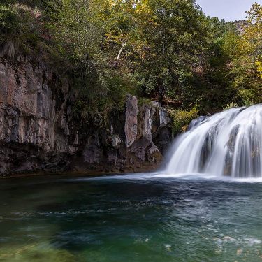
Hidden Falls
Why you should go: Beautiful waterfall and swimming holes in the Sierra Foothills
Difficulty: Easy
Distance: 8.8 miles
Elevation gain: 1,200 feet
Hidden Falls Regional Park has over 30 miles of trails for hikers, runners, and cyclists. The main attraction, however, is Hidden Falls. A viewing platform lets you see this waterfall plunge down below. If you look carefully in the rocks around it, you’ll see a rare native succulent (dudleya cynosa) found only in the Sierra Foothills.
Continue along the creek and you’ll find some excellent swimming holes — perfect for when it’s scorching in the summer or an early spring heat wave. In spring, you can find poppies and lupine blanketing the sunny hillsides.
Heads up: Reservations are required to hike here on the weekends to minimize impact.
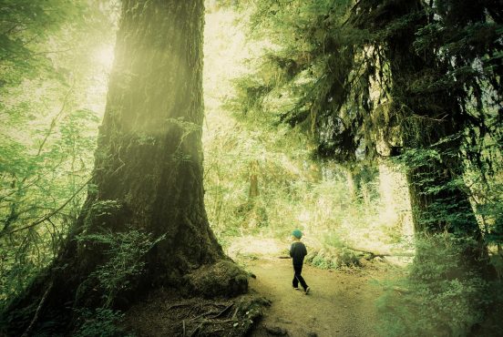
Sequoia Bayview Big Trees Loop
Why you should go: The closest redwood trees to Sacramento
Difficulty: Easy
Distance: 4 miles
Elevation gain: 270 feet
Honestly, there are redwood trees. Do you need another reason?
The Sequoia Bayview Big Trees Loop takes you to the Bay Area and famed redwoods, the tallest trees in the world. This loop has old growth redwood trees, an older variety that grew over a century ago. Thanks to their massive canopies, this hike is perfect for escaping the heat and smog in the Sacramento Valley. This spot’s proximity to the ocean keeps the weather temperate, and if you’re lucky, it’ll be blanketed in fog.

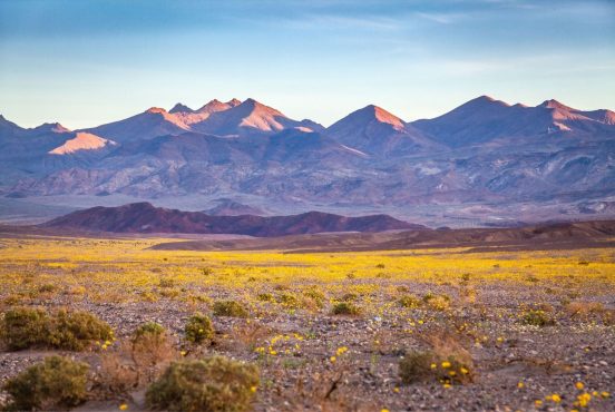
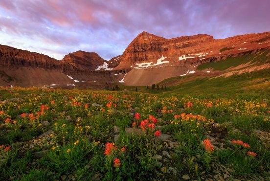
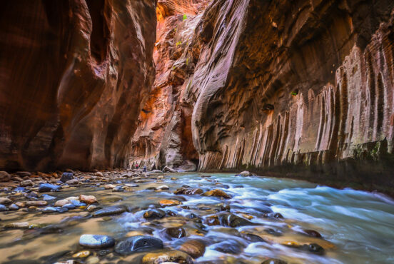
Phantom Falls and North Table Mountain
Why you should go: Wildflowers galore in the spring
Difficulty: Easy
Distance: 5 miles
Elevation gain: 700 feet
After a good winter, North Table Mountain erupts with wildflowers galore. Poppies, lupine, monkeyflower, and more blanket the fields in this area. A good winter also means Phantom Falls is in! This is a seasonal waterfall that’s best seen in the spring, but even if there’s no water, the basalt formations make you feel like you’re in Iceland.
Technically, there are no trails here, but North Table Mountain sees enough traffic that you can easily figure out where to go. Most folks do a small loop around Phantom Falls and back, but there’s plenty more to be explored if you feel like going on a quest. Several other waterfalls can be found at this ecological reserve, but there are no trails to them, so you need to be adept at navigating.
Dogs are welcome here, although you’ll need to keep them on leash because this is cattle grazing land. A Lands Pass is required per person to hike here. This can be purchased online while you’re at the trailhead.
Dipsea Trail, Steep Ravine Trail, and Matt Davis Loop
Why you should go: A Bay Area classic with a funky wooden ladder
Difficulty: Moderate
Distance: 6.7 miles
Elevation gain: 1700 feet
This loop is a classic for every Bay Area hiker, and the trailhead squeaks in at exactly 2 hours from Sacramento — a reasonable drive for a day hike, in our opinion. This trail begins at the coast and climbs up Steep Ravine. Steep Ravine is a cool, lush, and shaded area along Webb Creek. The stunner of this hike is the 10 foot climb up a ladder next to the waterfalls.
It’s quite popular with the Bay Area hiking crowd, so you’ll need to start your hike early in order to find parking and solitude.
Seen in: California, Hikes, Hiking, Hiking in California